|
When a city is suffering from floods, how do we get the latest report on the disaster?
When a forest fire takes place, how can we form a full picture of its impact?
When an oil spill occurs, how can we most immediately monitor the pollution?
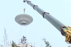
You don't have to go far to get the answers. They can be found inside the spherical structure on the hilltop on CUHK campus. The installation is called the Satellite Remote Sensing Receiving Station.
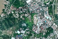
Traditional ground investigation is time-consuming, thus Satellite Remote Sensing became the most effective way to collect information on the earth’s surface. It is the Station that captures the data and images from the satellite and converts them into valuable information for monitoring the environment.
The Satellite Remote Sensing Receiving Station is an important facility of the Institute of Space and Earth Information Science (ISEIS) of CUHK. As the only national base for satellite remote sensing in Hong Kong, the institute is equipped with the first high resolution satellite remote sensing ground receiving station. The familiar giant white sphere is actually a protection mask. The important part is an antenna inside of the mask, which is 9 meters high and 7.5 meters in diameter.
Since 2005, the Station has helped the MTR Corporation to monitor the stability of railway track and observed the glaciers and frozen ground on the Tibet Plateau to track the stability of the roadbed for the Qinghai-Tibet Railway. It has also provided regular reports on Poyang Lake for water resources management, and has been monitoring impervious surfaces of Hong Kong for analysis and modelling of the urban settlement environment. In fact, the operation of the Station can cover every aspect of our daily life.
Besides supporting various research projects, ISEIS has also taken part in international disaster management. It has cooperated with the United Nations Economic and Social Commission for Asia and the Pacific (ESCAP) to organize internship and training programmes. The students from CUHK have also taken up significant tasks to enhance disaster reduction ability in the region.
Let’s now follow Prof. Lin Hui, Director of ISEIS into the Station and explore the secrets of environmental monitoring by satellite.
|


