 |
In October 2004, The Sustainable Development Unit (SDU) of the Administration Wing of the Hong Kong Special Administrative Region Government (HKSARG) commissioned a study to update the Terrestrial Habitat Mapping and Ranking for Hong Kong based on conservation value using the latest remote sensing and geospatial data and data collected from field survey.
The Joint Laboratory for GeoInformation Science (JLGIS), The Chinese University of Hong Kong, in association with Scott Wilson Ltd, submitted a proposal and was later chosen by the SDU among several organizations to carry out this study.
|
After a four- month dedication to the project by a team consisting of professors, technicians, field surveyors, and graduate and undergraduate students from the CUHK and partners, all tasks were successfully completed by the end of March 2005. The project major deliverables include:
- Digital Terrestrial Habitat Map and Conservation Assessment Map of Hong Kong based on 2004 SPOT Satellite Image and other geospatial data (Figure 1 and 2)
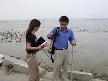
- An expensive field database of 370 sites surveyed throughout Hong Kong land territory (Figure 3 for an example of field survey).
|
 |

Figure 3a: Example of field survey
|
This Study provides the most up-to-date information with regard to habitat types and conservation values for Hong Kong. The habitat map, as one of the key deliverables of the project, allows for quantification and assessment of existing natural habitats and study of its status and trends when compared with the habitat maps developed in the previous studies. The conservation ranking map for each habitat portrays in detail areas with various levels of conservation status, and provides useful information for sustainability assessment.
The field database not only includes information on habitat type and status, but also detailed information on plant species and communities and the importance regarding conservation of different habitat types. The 360-degree panoramic photos along with GPS location provide a first-hand dataset for each site surveyed.
|
