News Centre
CUHK Professor Investigates Extremely Shallow Earthquake Related to Shale Gas Production in Sichuan
Professor Hong Feng YANG at the Earth System Science Programme of The Chinese University of Hong Kong (CUHK) recently conducted a comprehensive study of the 2019 earthquake sequence in Weiyuan Shale Gas Field (WSGF) in the southern Sichuan Basin of China. It was found that the 25 February 2019 earthquake occurred at around 1 kilometer below the surface, an extremely shallow depth where earthquakes do not generally happen. There is also evidence that the earthquake was induced by the shale gas production nearby. The findings not only advance our understanding of earthquake physics, but also hold important implications for seismic hazards in shale gas fields. The research article has been published online in Seismological Research Letters.
Evidence suggests earthquake triggered by hydraulic fracturing
The earthquake occurred at 1:15 pm on 25 February 2019 and had a local magnitude (ML) of 4.9. Two foreshocks with magnitudes larger than 4 occurred nearby, around 20 and 4.5 hours before the ML 4.9 quake. These earthquakes struck Rong County, where shale gas production has been rapidly developed since 2012. To extract oil and gas from low-permeability shale rocks, hydraulic fracturing (also termed fracking), a technique of injecting high-pressure fluid to create fractures in rocks, is commonly used to increase the permeability within the reservoir. Since it has been extensively used in the shale gas industry, a significant number of earthquakes induced by fracking have been reported worldwide, including in Canada, USA, UK, and China.
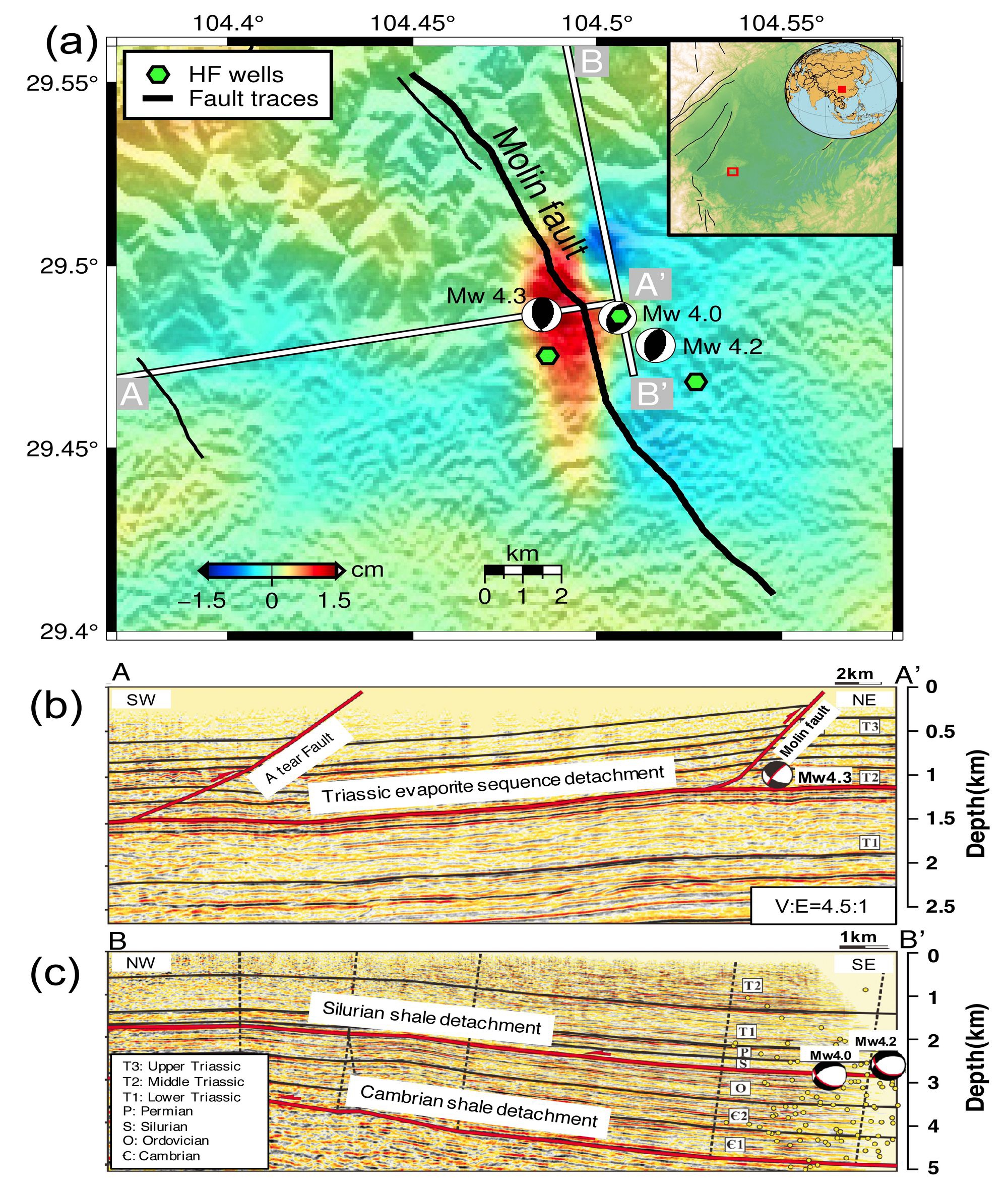
The two foreshocks are found to have occurred at depths of around 2.7 kilometers, coinciding with the fracking depth. Before the main shock, fracking activities were going on at nearby injection wells. The spatial and temporal correlations suggest that these two earthquakes were induced by fracking, possibly through increasing pore pressure on the fault and thus leading to fault slip. The ML 4.9 quake, however, was constrained to a much shallower depth of 1 kilometer. Professor YANG and his collaborators at Central South University observed clear ground deformation on satellite images, which was rare for an earthquake of such magnitude but confirmed its shallow depth.
Discovery of extremely shallow earthquake enhances understanding of the field
The extremely shallow depth is the major reason for the destructive damage and two fatalities, despite its moderate magnitude. Furthermore, Professor YANG and his graduate students found that the two foreshocks did not occur on the same fault as the ML 4.9 main shock, raising a critical question of on which faults they occurred.
Using high-quality seismic reflection data, Professor YANG and collaborators from Hohai University identified the source faults of these earthquakes. The two foreshocks ruptured the detachment fault dated Silurian, within the shale layer. The main shock occurred on the Molin fault, a geologically mapped west-dipping reverse fault with a depth extent of around 1.5 km. The very shallow portion of a fault at depths of less than 2 km is usually considered aseismic. However, the Molin fault is exceptional, marking a rare record of extremely shallow rupture. The findings were published in Seismological Research Letters on 19 August 2020.
Due to the high demand for energy resources, fracking will continue and likely intensify in the Sichuan Basin. Therefore, evaluating relevant seismic hazards is critical. The new findings by Professor Hong Feng YANG’s team pose a new challenge in how to properly assess the earthquake hazard for very shallow faults, which are commonly thought aseismic. It is fundamentally important not only for earthquake physics but also for the secure and sustainable development of the shale gas industry. Moreover, the results also highlight the importance of collaborative efforts among different stakeholders such as industry, academia, and policy makers to formulate effective strategies to mitigate risks of induced earthquakes.

